A History of Panners Lane and Driefontein Farm
By Malcolm Wilson
Early Settlers and Prospectors
The history of Panners Lane and Driefontein Farm is connected to the arrival of the earliest hunters, settlers and prospectors who crossed the Vaal River in the 1830s and 1840s.
The history of Panners Lane and Driefontein Farm is connected to the arrival of the earliest hunters, settlers and prospectors who crossed the Vaal River in the 1830s and 1840s.
In 1834 Carel Krige, a hunter, is said to have discovered alluvial gold in the Jukskei River near the confluence of the Crocodile River. This was technically the first discovery of alluvial gold on the Witwatersrand.
In the 1840s ownership of farms was undocumented and rudimentary allocations were made by the initial South African Republic the capital of which was Potchefstroom.
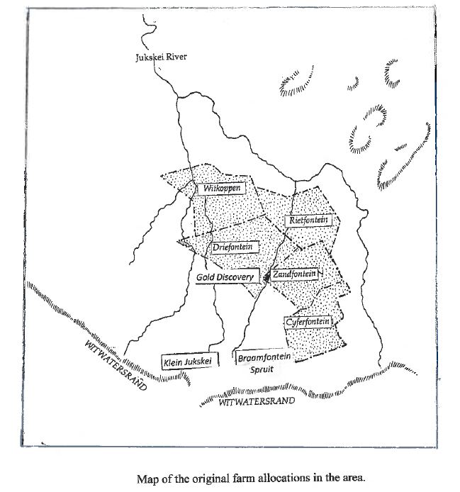
Amongst the allocated farms was Driefontein Farm owned by LP van Vuuren and Zandfontein Farm owned by Pieter Nel and later JC Esterhuizen.
In 1852, gold was found on the Witwatersrand by the Welsh geologist John Henry Davis on the farm Paardekraal (Krugersdorp). The find was kept secret by the government to avoid a possible influx of prospectors and Davis was deported from the boer republic.
In 1853 a prospector Pieter Jacobus Marais travelling between Potchefstroom and what is now Pretoria, found traces of alluvial gold at the confluence of the Crocodile and Jukskei Rivers.
Later the same year, he stopped to pan for gold in the Klein Jukskei River today the Braamfontein Spruit.
Marais kept a journal of his activities and in the entry dated 9 October 1853, he wrote:
“Found some gold at Piet Nel’s on the Klein Jukskei River.”
According to research by Dr Jane Carruthers, the farm concerned was Zandfontein Farm which was owned by Nel at the time.
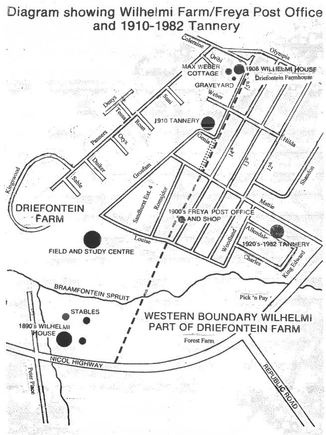
Zandfontein Farm (now Sandton central) had a very short frontage along the Klein Jukskei (Braamfontein Spruit).
The gold find by Marais was therefore close to where the Nicol Highway bridge crosses the Braamfontein Spruit.
See map.
Marais reported his find to the Volksraad but history is silent about the result. It is believed that he was ordered to keep the find secret in case the hated “uitlanders” (foreigners) moved in to exploit the opportunity. Unlike Davis, Marais was not deported.
It is recorded that the quantity of gold found by Marais soon ran dry.
The main reef of the Witwatersrand was only found in 1886 by George Harrison.
In order to appreciate Panners Lane’s origins, one needs to examine the well documented history of Driefontein Farm.
History of Driefontein Farm
The first farmers to settle in the Transvaal allocated large farms to themselves which were ill defined. In order to demarcate a farm the owner selected a point and measured the next point whilst riding a horse at walking pace for 1½ hours. He would then walk a further 1½ hours at right angles to establish the third point.
The original Driefontein Farm established in the 1840s included most of what is today Riverclub (including the golf course), Bryanston and Randburg.
Driefontein Farm was first owned by LP van Vuuren and then purchased by JJC Erasmus and thereafter by Johannes Lodewikus Pretorius.
The Deeds Office in Pretoria was first established in 1859.
Pretorius became the first owner officially registered by the Deeds Office in Pretoria.
Pretorius came into possession of 3422 morgen (2931 ha), stretching from the present suburbs of Witkoppen to Craighall. The three springs (drie fontein) suggested by the name, have not been located but it is known the Braamfontein Spruit ran through the original property.
According to research by Carruthers, Pretorius sold approximately 894 morgen (the south-eastern part of Bryanston), to Antonie Smit in 1877. Pretorius continued to farm the remaining portion.
When Pretorius died in 1888, the farm was divided amongst his nine sons, each of them paying ?60 for a 280 morgen share. The value of the land had risen considerably since 1886 when gold was first mined on the Witwatersrand and Johannesburg established.
In 1890, one of the Pretorius sons Gerhadus Jacobus, bought his brothers’ portions and consolidated the farm again. But as the town spread northwards, he began to sell off portions, one of which was bought by Herbert Gladstone Nolan.
In 1893 Nolan sold 51 morgen to adventure-seekers and recently married Adolf and Elsa Wilhelmi who had arrived in Johannesburg from Germany in 1891.
Elsa Wilhelmi was born in 1871 in Germany and came from an old aristocratic family.
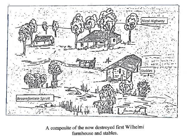
The Wilhelmi’s first house was a corrugated iron shack on the Forest Farm side of the Braamfontein Spruit. They later built a stone house near a bend in the river.
The house was located close to what is now the Nicol Highway and immediately west of the stables of which the stone walls are still standing.
See drawing.
In 1899, the family sub-divided their land and sold 9.56 morgen to the Salvation Army. The property was later taken over by the Transvaal Association for the Care of Cerebral Palsied (TACCP) who established Forest Farm in the 1980s. A portion of their property was sold to Pick ‘n Pay in the early 2000s for the development of a supermarket.
The Wilhelmis also sold 42 morgen to Ralph Sandilands Arderne. He was known as Dunny and was a good family friend of the Wilhelmi’s. He had in the past helped Wilhelmi acquire the farm Driefontein 3. Arderne lived on Driefontein for years and died in 1935.
When the Wilhelmi’s daughter Freya was a baby Arderne gave her a gift of 2 morgen of land on the Forest Farm side of the river.
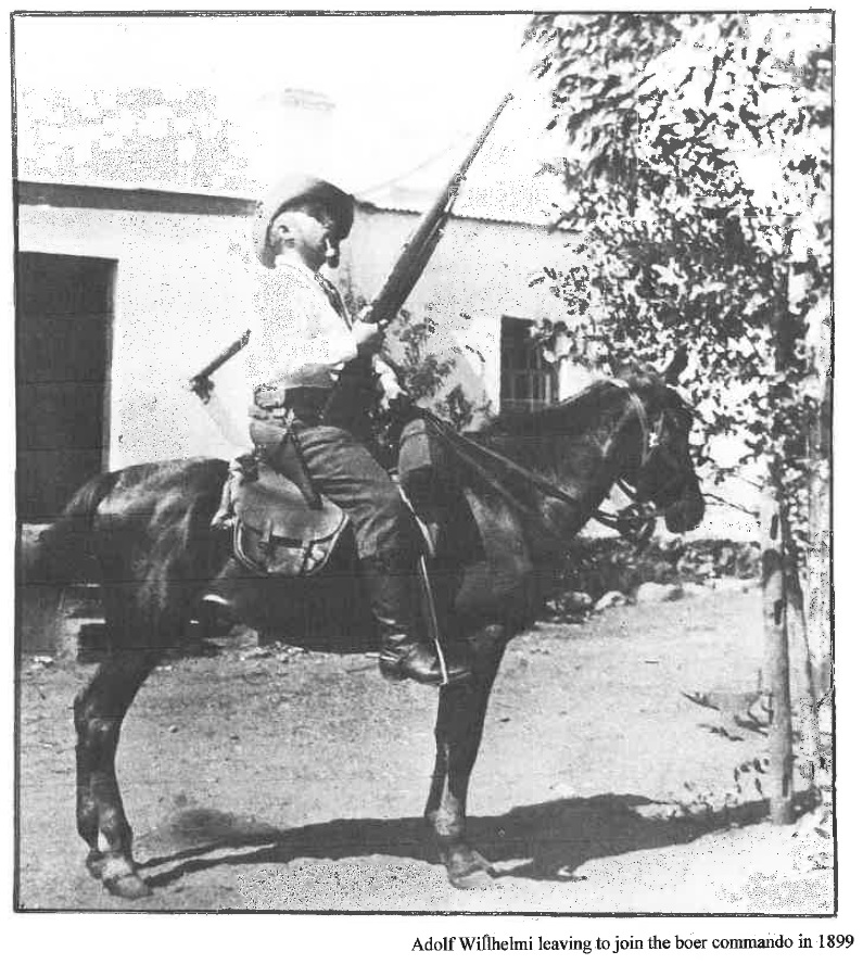
During the South African War of 1899 – 1902, Adolf joined a Boer commando under the command of General De La Rey. He was later captured by the British and given the choice of being sent as a prisoner to St Helena or South America. He requested transfer to Germany and to his surprise his wish was granted.
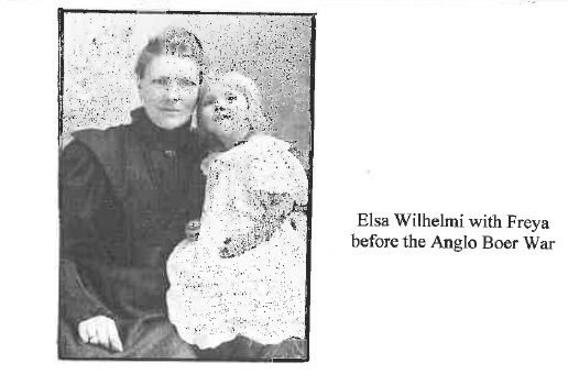
In the meantime, Elsa had abandoned the farm and travelled to Germany in 1902 with their daughter Freya and their new born son Willfried. Elsa and Adolf were reunited in Hanover.
On their return from Germany after the war, they found their house burnt out and all the furniture gone, much of which they recognised in other houses in the area.
The Wilhelmis became tenants on their previous farm courtesy of Arderne. In 1906, says Carruthers, Arderne generously gave them back almost half the land (some 20 morgen) he had bought from them in 1899.
Adolf dammed a section of the Braamfonten Spruit, below what is now the Field and Study Centre house. The dam became a favourite picnic spot for the German community of Johannesburg.
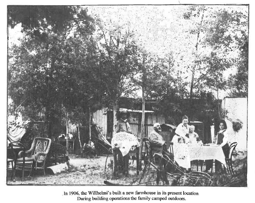
The Wilhelmis built Driefontein Farmhouse in its present location on the corner of 15th Street, Parkmore and Coleraine Drive in 1906.
The Wilhelmis planted many hectares of wattle trees for tannin extract. A tannery, first established in 1910 was located at what is now the corner of 15th St and Genia Ave in Sandhurst Ext 4. The tannery moved in the 1920s alongside the Braamfontein Spruit near the crossing what is now the Nicol Highway (built in 1956). The tannery, later partially owned by Norman Berg, was demolished in 1984 and the land became the suburb of New Brighton adjoining Parkmore.
Apart from wattles, the Wilhelmis planted many fruit trees and vegetables which were sold in the market of the growing town of Johannesburg.
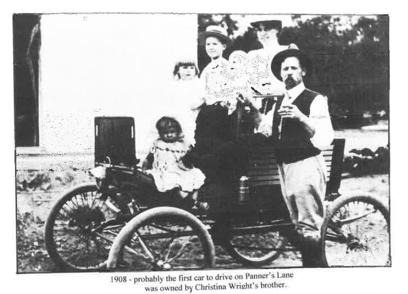
The foreman of their farm was Ernest George Wright. George and his wife Christina moved into the Wilhelmi’s old stone house in 1908. Christina’s brother was the owner of one of the first cars in Johannesburg and brought it to Driefontein Farm. He was probably the first person to drive a car on what was to become Panners Lane.
Elsa and Adolf had 7 children. The first was stillborn, followed by Freya Franziska Mary-Anne, Norman who died at the age of 3 and Willfried who were born before the South African War. Erwin, Ursula and Ulrich (known as Tickey) were born after the family returned to South Africa.
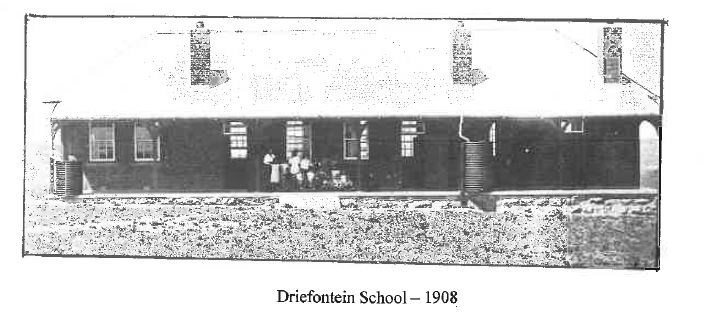
Most of the Wilhelmi children attended the Driefontein School which was built in what is now Parkmore in 1912. It is not known when the school closed.
As a child, Freya was taught by her mother and was sent to the German School in Johannesburg at the age of 12. But she was so homesick that her father brought her home and she never went to school again.
Adolf died in 1925 in Kimberley, by which time he was legally separated from Elsa.
Elsa died in 1948 and her and other gravestones are located at Driefontein Farmhouse.
The Weber Family
Max Weber was born in 1874 in Switzerland and trained as a manufacturer of scientific instruments. In his early 20s, says researcher Avril Reid, he decided to go to America but on the dockside of Marseilles harbour, he impulsively changed his mind and jumped aboard a ship for Cape Town.
In 1900, it is recorded that Weber was fighting for the Boers in Natal where he was wounded and sent to Johannesburg to recover. Later that year Johannesburg was taken by British forces. Weber fearing arrest, took refuge north of the town, possibly on Driefontein Farm where he met the Wilhelmi family, says Reid.
After the war Max developed a passionate interest in geology and became an accomplished geologist, building a laboratory near the farmhouse. He later became curator of the Johannesburg Geological Museum which is now incorporated into Museum Africa.
Max was appointed as consultant geologist to the Messina Copper Mines and was a friend and partner of Dr Hans Merensky who discovered the Bushveld Complex of platinum reserves.
“Over the years Max Weber developed a reputation for his ability to recognise different minerals and was regarded as a scientist of distinction”, says Reid.
One of the sons of JL Pretorius, Mathys sold his share of the property to JJ Mostert. On his death in 1910 the property was sold to CFEO Schmit. Two portions were later bought by Max Weber in 1914.
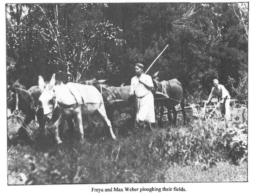
Max also bought Driefontein Farmhouse and land adjoining Freya’s own small farm from Elsa Wilhelmi. He subsequently married Freya, extending her farm with the addition of his two pieces – 5.5 morgen and 10.2 morgen.
At the time of their marriage in 1914 Max was aged 40 and Freya 23.
Max was described by author Juliet Marais Louw who lived on nearby Benmore Farm, as a “modest and self-effacing man”. She described his laboratory as having the “air of an alchemist’s den”.
The laboratory was later altered by Leo, Max and Freya’s son, and became known as Railway Cottage because of the number of railway sleepers used in the alteration. It was demolished in 1990.
There was a small shop and an official post office on the farm called “Post Office Freya”. The post office was located on the western boundary of the farm (Now 14th St. Parkmore - off Louise Ave.)
Freya was an avid reader and according to Carruthers, “had a great sense of humour and a bubbling personality which endeared her to everyone who met her”.
Max’s income from the Messina Copper Mines meant that the family didn’t need to rely on farming to earn a living. Freya however, loved farm work and “continued to the end of her life more or less as she had done in the lean years of her girlhood” said Carruthers.
Freya used to make trips to the Johannesburg library and bring back books for the family and her mother, who read in German, Afrikaans, English, Hollands and a bit of French.
In 1937, Freya sold the lower part of the farm to Philip and Emma Arnold who built a large house and farming operation (now the Field and Study Centre). The family maintained cows, grew lucerne and asparagus. When their son Wolfgang died in 1974, a provision in his will gave the Sandton Town Council first option to purchase the property. The council exercised the option and established the Field and Study Centre.
Today Weber Close (off 15th Street Parkmore and zoned Riverclub Ext 10) is named after Max Weber.
Weber died in 1948 and Freya continued to run the farm until her death in 1963, leaving the farm to be divided between their sons, Norman and Leo.
In 1968 Norman sold the entire property with the exception of Driefontein Farmhouse then on
1.7 ha. of land.
A section of Driefontein Farm was sold to the Grosman family who later developed the suburb named Sandhurst Ext 4. The family converted the first tannery building to a house. The road on which it stands is named Grosfam Road.
Later Developments
In the early 1980s, Driefontein Farmhouse was threatened with demolition after the proposal of a road-widening scheme in the area. In 1983 the proposal was however dropped and the house was saved.
In August 1983 Driefontein Farmhouse was auctioned and bought by Constantino Callegari for R200 000. He later sold the farmhouse to Dr Bruno Foli, a property developer, who donated it to the Sandton Council in 1989. The condition was that the house had to be used as a “cultural centre and serve as the headquarters of the Sandton Historical Association” according to the Sandton Chronicle of 21 July 1989.
In 1990, the house was renovated and an ablution block built. In the process the original kitchen and bathroom, both considerably dilapidated, were demolished. Two Wilhelmi gravestones from a nearby woodland were moved to the garden of Driefontein Farmhouse.
Replacing the busy farming settlement which once contributed to Johannesburg’s fresh fruit and vegetable needs, the house is today surrouonded by upmarket houses and townhouse complexes.
The now defunct Sandton Historical Association used the farmhouse for meetings in the 1970s and 1980s. The organisation conducted vital research into the history of the area and their journals are stored in the basement of the William Cullen Library at the University of the Witwatersrand. There is a big gap for this research work to resume.
Driefontein Farmhouse is currently owned by the Johannesburg Municipality and leased to a caretaker until a decision is made what to do with the building.
Panners Lane – The Story of a Road
Long before the establishment of Sandton as a municipality in 1969, the area was managed by the Transvaal Board for the Development of Peri Urban Areas.

The Board developed rudimentary maps and in the absence of names for roads, designated the name Road 202 to what is now Panners Lane.
The road branched off Shiel Ave (now Coleraine Drive) and became a dead end near the Braamfontein Spruit.
In the 1920s the Pilkington family ran a popular tea garden named Pilkyvale which was located in what is now Benmore. Later they bought the property located on the eastern side of Road 202. In the late 1940s the family divided the property into four smallholdings for sale to the public.
The first stand (Riverclub Ext 5) on the corner of Shiel Ave, was bought by Hugh and Florence Walters.
The property was later bought by the Goldfields Mining Group. Various proposals for development including a hotel were considered.
The property fell into disrepair and old stables on the border of Panners Lane were used as a shebeen for some years.
A later proposal considered was to build apartments with a density of 78 units per hectare. This was completely unacceptable to residents in the area and with the assistance of Rose Johnson, the proposal was defeated.

In due course the owners of the property agreed to a density of 20 units per hectare and Riverclub Estate was built in 1994.
On the adjoining stand (Riverclub Ext 4), Peter and Joyce Kisch built a large home designed by Stefan Ahrents. Peter was a partner in the long established firm of patent attorneys DM Kisch Inc. The house was named Flint Farm after the artist Sir William Russell Flint who was a personal friend of the Kisch family.
Four dams were built on the small river running below Denys Road. One dam in a fenced off area survives and is owned by the municipality.
Panners Lane in those days was a rudimentary dirt road. Residents were forced to turn out and repair the roads themselves after heavy rains.
Tessa and Denys Roads were constructed in 1981 and named after the Kisch’s two eldest children.
David (DAB) Watson the CEO of JCI Mining and his wife Margaret bought the Kisch property in 1968.
After the death of David Watson in 1971, Margaret married Graham Murray, the owner of Murray Pools. Margaret sold half an acre of Flint Farm to Pam Ronbeck (now Wilson) in 1978.
One of Margaret’s daughters Elizabeth Dooley owns one of the subdivided properties and has lived in the area since 1971.
After Margaret’s death in 2006, the house which had been declared a heritage house, was demolished to make way for the current cluster house development. The name Flint Farm was retained.
Len and Muriel Fisher bought the third 5 morgen plot (Riverclub Ext 33) in 1949.
When the Fishers settled in such a rural area, their urban friends decided they were crazy to bury themselves in such a remote area and their house was dubbed Fisher’s Folly. The name was later changed to Folly Farm when the joke started wearing thin.
Len was a founding partner of the patent attorneys Spoor and Fisher. He was a Democratic Party councillor for Johannesburg for a number of years. After the death of Muriel in 1984, Len married Audrey in 1986. Len died in 2004 and Audrey in 2007.
Part of the property was sold in 1988 and the complex Humewood Links was developed in 1991. In
2014 Folly Farm (20 Panners Lane) became a cluster house development.
In the 1950s, Fred Pilkington, son of the owner, built a new house on the fourth property and lived there until 1976. He applied for township rights in conjunction with Kingswood Estates which adjoined his property.
The entrance to Kingswood Estates was at the end of Panners Lane and was owned by a woman who later emigrated to England. The property stretched down to the Braamfontein Spruit. A market gardening farm was developed and managed by a Mr Gouveia until the late 1960s. The house on the property was unusual in that the walls contained a façade of pebbles set into the plaster.
In the 1940s and 1950s, access to what became Panners Lane was via Parkmore which was undeveloped. A few small shops in Eleventh Street, a sprinkling of cottages in Fourth and Fifth Streets and the defunct Driefontein School were the only existing buildings. The old school building stood out on the crest of Parkmore and served as a site office for Roberts Construction who built most of the houses in Parkmore. The building was demolished in 1961.
Road 202 was a dust road and later acquired the name Tsessebe Road. All the other branch roads were given the names of buck, Oribi, Suni, Roan, Oryx, Duiker and Sable.
Nyala and Gnu Roads were incorporated into Riverclub Estate. Impala Road was absorbed into Humewood Links.
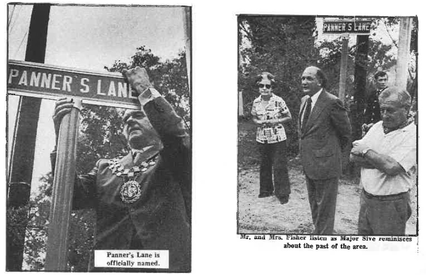
The residents of Road 202 objected to the name Tsessebe as they wanted some record of the original discovery of gold in the Braamfontein Spruit in the naming of the road. After many suggestions such as Goldfinders Lane or Marais Lane, Jonathan Fisher, Len and Muriel Fisher’s son, came up with the name – Panners Lane.
Then came the battle to have the proposed name recognised. Efforts by Len Fisher to have the road named under the Peri-Urban Health Board failed. Sandton became an independent town in 1969 and in 1973, the matter was taken up by the Ward 3 Ratepayers Association and eventually passed by the Council. Even then there were delays as the Provincial Administration had to sanction the new name.
It was not until 22 February 1975, that the Mayor of Sandton, Clr. Bill Hedding, Major Reuben Sive, Chairman of the Sandton Historical Association and Len Fisher, put up the metal nameplate at the corner of Shiel Ave (now Coleraine Drive) and Tsessebe Road, that Panners Lane was formally named.
The local residents, their children, dogs and bicycles crowded the road and after the ceremony and speeches, everyone went for a braai at Margaret Murray’s house. The Sandton Chronicle carried the story in full with photographs, including one of the Mayor re-enacting the panning of gold. The November issue of the same year carried a photograph of Jonathan Fisher with his bride on their wedding day standing below the sign Panners Lane.
Panners Lane was finally tarred in 1980.
In 1988, the Transvaal Provincial Government announced a proposal to establish a major link road between Randburg and Alexandra township. The intention was to open the Randburg CBD to become an important commercial and retail hub with good road access from east to west.
The project called the PWV3 or South Road Development, was intended to cross the Braamfontein Spruit at the Field and Study Centre, through the gum tree park at the bottom of Panners Lane, over empty land (now Savannah), the border of the River Club Golf Course and on to South Road Morningside.
Under the leadership of Carlo Chelazzi, the proposal was fiercely fought by property owners throughout Sandton. In 1993 the Province backed down and the project was cancelled.
Ratepayers Associations
After the establishment of Sandton as an independent municipality, a number of wards were created. Riverclub fell under Ward 3.
Ward 3 was later divided into Wards 10 and 15.
Originally the Ward 15 Residents Association included both Riverclub and Morningside. The Association was chaired by Willem Hefer and later Rose Johnson .
In 1988 the residents of Panners Lane decided to break away from the Ward 15 Association and Ward 10 created their own Residents Association.
The first chairman was John Lambson and the treasurer Carlo Chelazzi.
An important function of the new association was to fight the proposal for the PWV3 road development.
After this battle was won, Carlo Chelazzi became chairman but the Ward 10 Association was disbanded soon after that.
Shortly after the disbandment, the Riverwards Ratepayers Association was established. The association incorporated the Ward 10 and 15 suburbs Riverclub, Morningside Ext 40, Sunset Acres and Moodie Hill. John Lambson became chairman. Malcolm Wilson became chairman following the death of John Lambson in 2001.
With the introduction of boomed enclosures in most suburbs, the Riverwards Ratepayers Association became defunct in 2003 due to a lack of interest.
Following the 1994 elections, the African National Congress took over national and local government in Johannesburg.
Shortly after that, legislation was changed regarding the structure of municipalities.
In 1999, Johannesburg became a metropolitan council which incorporated various other municipalities surrounding the city.
Sandton, Edenvale and Alexandra were incorporated and became known as the Eastern Metropolitan Sub Structure of the Greater Johannesburg Metropolitan Council.
As part of the restructuring, Riverclub and surrounding suburbs became part of the new Ward 103.
The Panners and Kingswood Village Association (PKVA)
Due to rising crime rates in the late 1990s, a guarded boom gate at the top of Panners Lane was established. The PKVA enlisted subscribers to pay for the security.
The founding chairman of the PKVA and designer of the original boom gate was Carlo Chellazzi.
Subsequent chairmen of the PKVA were Wolf de Villiers, Mike Duncan, Malcolm Wilson and Steve Buck.
A palisade fence and lock up gate at the entrance to the Field and Study Centre Park was erected in 2006.
Over the years, security was improved with the introduction of cameras and a card access system in 2012.
After years of approaches to the City Council, street lights on Panners Lane and Kingswood Crescent were erected in 2013.
Rainfall Records in Panners Lane
Records of rainfall in Panners Lane were maintained by Len Fisher from 1962 until 1997.
The records in fact go back to 1947 thanks to the late Sandton Councillor Bob Wessels who gave the information to Len.
The year ended 1996 was by far the wettest year during the time records were kept. The annual rainfall was 1060 mm (41.7 inches). The next wettest years were 1987 (918 mm) and 1995 (856mm).
The average annual rainfall for Panners Lane is 628 mm(24.7 inches).
The lowest rainfall on record was 331 mm (13.0 inches) in 1965.
The highest monthly rainfall on record was in March 1997 at 300 mm (11.8 inches).
Records have not been kept since mid 1997. Residents who are keen to revive the record keeping, should contact Malcolm Wilson.
Editing Notes
A number of observations were taken from my own recollections of the area when I was a small boy in the 1950s.
My edited summary is partly adapted from information obtained from two websites, the Heritage Portal www.heritageportal.co.za/driefonteinfarmhouse and GC2JC7M Driefontein Farm House www.geocaching.com
An article “The Lost Houses of Driefontein” is on the Heritage Portal website and an important source of reference.
A definitive source of reference is the Annual Magazine of the Sandton Historical Association (No. 15 of 1991) which contains detailed research by Dr Jane Carruthers and Avril Read on Driefontein Farmhouse, the Wilhelmi and Weber families.
Dr Carruruthers book “Sandton – The Making of a Town” (Celt Books 1993) was a valuable source of information.
A further source is taken from a document on the history of Panners Lane prepared by Muriel Fisher in 1980. Muriel’s writing contains a fair amount of detail from the perspective of her own family.
Another source is the book Wagon-Tracks and Orchards by Juliet Marais Louw (AD Donker 1976).
There is a chapter in the book, “The People of Driefontein” including a number of historical photographs. The Weber family were personal friends of Juliet and her family who lived at Benmore Farm in the early 1900s.
Others who helped in the research include James Ball of the Heritage Portal, Luke Goncalves a descendent of the Wilhelmi family, Neil Kisch, Rose Johnson of Friends of the Field and Study Association, Wolf de Villiers, Jonathan Fisher and Roger Bax de Keating.
Margaret Houliston of the Sandton Library provided assistance particularly with regard to articles in the Sandton Chronicle.
I would like to thank all those who helped with the research.
Malcolm Wilson
10 Panners Lane
River Club
Cell: 083 369 0875
Tel: 011 884 3355
© PKVA 2015-2024 Terms and Conditions | Privacy Policy
Sponsored by ![]()